It’s May (obviously), and if you’re like me you’re super angry to see the word snow being thrown around willy nilly. Well, it’s real and it’s coming. On the bright side, this is a quick-moving storm with things beginning to clear out Wednesday and Thursday.
Right Now

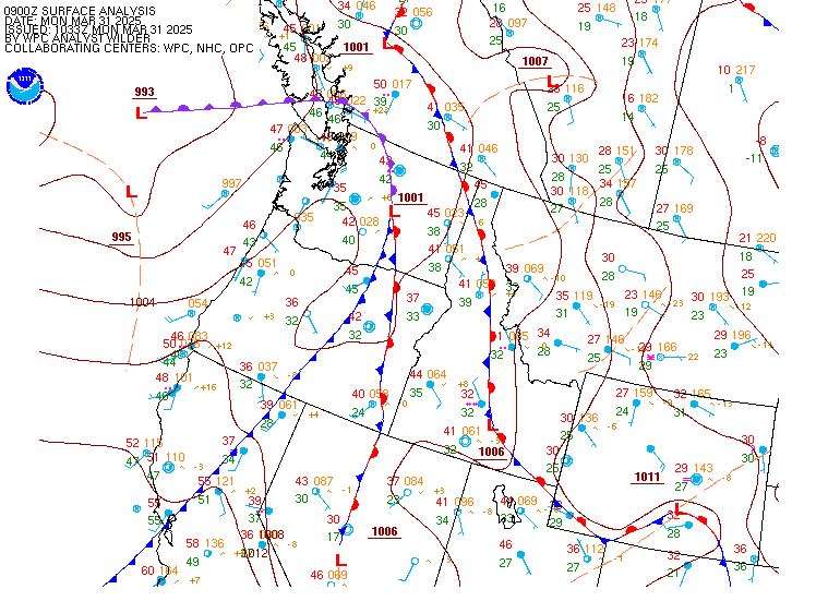
First, here’s a look at the surface analysis over the Pacific Northwest with data from 12 pm Mountain Time. You’ll notice a low located near where Washington, Oregon and Idaho meet (labelled 1004) with a front dropping south out of it.
This low is going to continue its southeast movement over the next day, tracking it over states such as Idaho and Montana.
As of writing, this storm is dumping snow in the mountainous areas of Washington and Oregon. Snow fell on Snoqualmie Pass east of Seattle (elev. 3022 feet) as well as on Cabbage Hill east of Pendleton (elev. 3620 feet).
Basic Details
As the system moves into the Northern Rockies, snow levels are looking to drop to around 3000-3500 feet in parts of Montana west of I-15 with them being around 4500-5000 in East Idaho and the Salt Lake Valley.
That being said, most of the significant snow amounts will be in the mountains themselves. Winter Storm Warnings are out for portions of Montana, Idaho and Nevada with Winter Weather Advisories for the mountains extending clear south to the Colorado/New Mexico border.
Impacts
Rain is already beginning to fall in Missoula and Boise with precipitation continuing to spread eastward during the evening. Overnight temperatures will drop (of course), allowing it to snow in some areas. By the looks of it, most of the impacts will be travel related.
 Passes on the Idaho/Montana state line are looking at a few inches of snow overnight and into tomorrow. Further north into Montana, over a half a foot of snow can be expected, especially along I-90 and I-15 around Butte.
Further south in Utah, the urban areas along the Wasatch Front will miss out on any snow of real substance. I-80 and I-84 going east out of Salt Lake might get some, but that will even be light. Higher passes, such as Teton near Jackson, Wyoming, will see higher amounts.
Temperatures Thursday will climb above freezing in most areas, allowing the snow to melt on roadways and other surfaces.
How Much Snow Will I Get?
Here’s a list of some cities and how much snow they will get:
Montana
Butte – 5-9 inches
Great Falls – Just Rain
Helena – Just Rain
Missoula – 1-2 inches
West Yellowstone – 1 inch
Idaho
Idaho Falls – Less than 1 inch
Pocatello – Less than 1 inch
Rexburg – Less than 1 inch
Twin Falls – Mostly rain
Utah
Brigham City – Mostly rain
Logan – Less than 1 inch
Ogden – Mostly rain
Park City – Maybe an inch. Maybe.
Provo – Mostly rain
Salt Lake City – Mostly rain
Wyoming
Afton – 1-2 inches
Evanston – Less than 1 inch
Jackson – 1-2 inches
Old Faithful – 3-6 inches


